To view in full screen, hover over the top right corner and click on the screen icon.
Category Archives: Covid-19
Map: Have School Attendance Rates This Year Varied by “Hardest-hit” Covid-19 Neighborhoods and Grade Levels?
Map prepared by Stephanie Kranes
New York City Independent Budget Office
What Impact Has the Pandemic Had on Job Placements for Cash-Assistance Recipients?
To view in full screen, hover over the top right corner and click the screen icon.
With a Restricted School Schedule, How Many Students With Disabilities Can Receive Their Related Services In Person?
Which Industry Sectors Have the Most Small Businesses and How Much Do Their Employees Earn?
How Much Did the 2021 Adopted Budget Reduce Spending For the New York City Police Department?
There Are More Municipal Workers Than Ever. But Is Headcount Up at All NYC Agencies?
Did the Number of Active Construction Sites Increase Even as the City Was on Pause?
When the City Went on Pause Did Parking Violations Plummet?
Which Neighborhoods Have More Nearby Park Space Per Capita?
The Covid-19 pandemic underscored the importance of parks and open space in the city’s neighborhoods, especially when many other amenities closed. Given the social distancing measures put in place to help limit the spread of the virus, equity of green space around the city—always an important issue—became even more important. In neighborhoods where park space is scarce, social distancing measures meant opportunities for passive recreation became more limited and exercise such as jogging or walking more difficult. While the new Open Streets program offers some additional space, vehicle-free streets are not the same as a park. IBO examined how the availability of park space per capita varies across New York City.
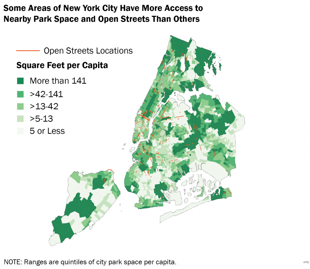
- Flagship, community, and neighborhood parks cover over 16,000 acres in the city, but park acreage is not distributed equally around the city. Neighborhoods such as Bensonhurst and Borough Park in Brooklyn and Jackson Heights in Queens have as little as two square feet of park space per resident. Chinatown and Stuyvesant Town in Manhattan and areas surrounding Parkchester in the Bronx also have limited park space per capita. Conversely, large amounts of park space per capita are found around Pelham Bay in the Bronx, near Bayside in Queens, and in several areas of Staten Island.
- Proximity to large parks such as Central Park, Prospect Park, Flushing Meadows Corona Park, and Van Cortlandt Park have a major impact on availability of green space for nearby residents. In particular, despite very high population density near Central and Prospect Parks, none of the neighboring census tracts are in the lowest two quintiles of park space square footage per capita.
- Recognizing that the Covid-19 crisis has increased the demand for outdoor space, the city introduced Open Streets from 8am until 8pm daily for use by pedestrians and cyclists and more recently, outdoor dining. While not providing green space, Open Streets does provide traffic-free space for residents to enjoy. Initially, many of the open streets were in areas already well served by parks such as northwest of Prospect Park in Brooklyn, near Flushing Meadows in Queens, and on the Upper West Side in Manhattan. But the program, which now covers 67 miles of streets, has expanded to serve areas with less park space per capita than elsewhere in the city such as Brownsville, Brooklyn and Jackson Heights, Queens.
IBO apportioned park space to nearby census tracts using a nearest neighbor analysis accounting for distance to the nearest park and assuming that many residents would walk up to a mile to a park. This assumption is less realistic for more car-dependent parts of Staten Island or eastern Queens, where it may be more common to drive to a park and green space outside the city park system is more abundant. The analysis also excludes non-green spaces operated by the parks department such as such as plazas or triangles, athletic facilities and recreation centers.
Prepared by Daniel Huber
New York City Independent Budget Office
Print version available here.
SOURCE: IBO analysis of data from the Department of City Planning and Department of Parks and Recreation